

Posts tagged with 'software'
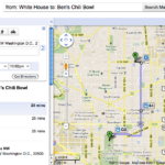
In a new partnership with the Washington Metropolitan Area Transit Authority (WMATA), Google announced a recent update to Google Maps that will now include all of D.C.’s Metro and bus stations, stops and routes, as well as connections to other ...

IBM, along with the California Department of Transportation (Caltrans) and California Center for Innovative Transportation at the University of California, Berkeley, announced a new effort to develop an intelligent transportation solution in managing traffic flow. The application, accessible through compatible smart ...

SeeClickFix released a Facebook application to encourage community participation and government accessibility in improving public spaces. Image via SeeClickFix. SeeClickFix, an online forum created to engage residents with community leaders to resolve neighborhood complaints, today announced the launch of a Facebook ...

Welcome back to TheCityFix Picks, our series highlighting the newsy and noteworthy of the past week. Each Friday, we’ll run down the headlines falling under TheCityFix’s five themes: mobility, quality of life, environment, public space, and technology and innovation. Mobility Obama’s ...
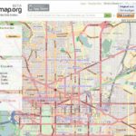
Via the blog, SupraGeography, written by Oliver O’Brien, a researcher and software developer at the Centre for Advanced Spatial Analysis (CASA), TheCityFix came across wheelmap.org. It’s a website (and iPhone app) built to display and aggregate information on wheelchair access in ...

Congestion pricing to reduce traffic and pollution; water systems that automatically detect leaks in pipelines and notify authorities; food that is tracked from farms to supermarkets to ensure food safety. These are some of the recent technological advances that are ...
This post is part of a series analyzing the solutions highlighted in the report and toolkit, “Megacities on the Move.” The report, written by Forum for the Future in partnership with FIA Foundation, Vodafone, and EMBARQ, offers six sustainable mobility ...
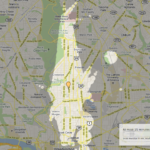
Above is an image of areas in the Columbia Heights neighborhood in Washington, D.C., specifically at Meridian Street and 14th Street, that are accessible within 15 minutes, thanks to a new mapping tool called Mapnificent, powered by Google Maps. Mapnificent is less ...
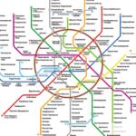
Moscow just released its new metro map. We thought it would be interesting to write about the most well-designed maps of various cities’ public transit systems. Moscow’s new map took four years to develop, according to the design firm behind it, Art. ...
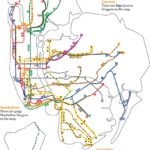
Maps are an important tool for visualizing data and space. New York City is blessed with one of the most comprehensive and well-designed maps of public transportation and biking. The city is also home to a highly educated population, which ...

The Transport Politic‘s Yonah Freemark has been writing recently about the efficiency of bikesharing models that major cities around the world have been adopting. He focuses on the issue of redistribution. Bikesharing systems have opened in cities, such as Denver, Co.; ...

Latitude, a Boston-based research consultancy, is asking interested volunteers to forgo using their cars for a week in order to investigate how cities, transportation providers and technology encourages the use of alternative transport (i.e. biking, walking, ridesharing) in San Francisco ...

City University London’s School of Informatics uses Geographic Information System (GIS) to map in real-time the city’s new shared bike system, Barclays Cycle Hire, to help predict and document bike usage and availability at each of the system’s 400 planned ...
Informed and engaged young people are key to moving transportation issues forward, bringing future advocates, citizens and practitioners into the next wave of transportation issues and smart transportation planning. This is especially important considering that the majority of youth – 85 ...

One asset of urban communities is that there are a lot of people living in them, which means plenty of opportunities to garner input from diverse people for research purposes. There’s a method for this kind of qualitative and quantitative ...

